
Some road trips leave you with a full camera roll. This one could rearrange your idea of what America looks like. Between Washington and California, the scenery changes from glacier-carved mountains to mossy rainforest, from a startling blue lake to steaming volcanic ground.
Give these eight parks room on the calendar, and the drive becomes a vacation worth anticipating for months. Here’s a north-to-south route built around the places you’ll actually want to stop, walk, and linger.
The route: mountains, ocean, volcanoes, and the Sierra
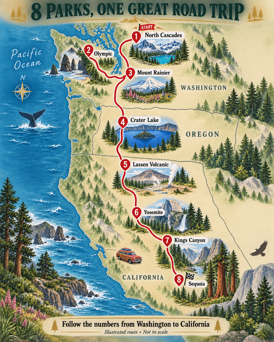
North Cascades → Olympic → Mount Rainier → Crater Lake → Lassen Volcanic → Yosemite → Kings Canyon → Sequoia.
Start with Washington’s North Cascades, swing west around the Olympic Peninsula, then turn toward Rainier before continuing south. Olympic creates a deliberate coastal detour. That detour earns its place with ocean beaches and rainforest you won’t find at the California stops.
Think roughly three weeks for the full trip, with extra time if you love hiking or prefer fewer hotel changes. Your overnight bases and chosen walks will shape the daily drive.
The full version suits the summer mountain-road season, usually with the broadest options in later summer. Snow, smoke, and construction can still change the plan. Choose dates around the high-country roads you most want to experience, then reserve lodging around those choices.
1. North Cascades: start with mountains that look unfinished
The North Cascades have a jaggedness that makes a familiar word like “mountains” feel insufficient. Peaks crowd behind peaks. Forests climb the lower slopes, then give way to pale rock and lingering snow. This is a dramatic opening act for a journey that still has seven parks ahead.

Diablo Lake supplies the famous color: a sweep of turquoise tucked between dark wooded ridges. Its roadside overlook is a fine first stop, especially when everyone wants a view before committing to a long walk.
A useful distinction: Diablo and Ross lakes lie in Ross Lake National Recreation Area, part of the North Cascades National Park Service Complex. The national park itself protects the wilder mountain country around that corridor. The roadside scenery and the backcountry belong in the same visit, but they aren’t interchangeable on a map.

Follow State Route 20 for overlooks, Newhalem’s forest setting, and the Gorge Creek Falls area. Give yourself permission to make several small stops. A waterfall framed by wet rock and trees can be just as memorable as the panorama everyone came to photograph.
For a more ambitious day, investigate Cascade Pass. The trail climbs from forest toward an alpine saddle, with mountain walls becoming more imposing as you rise.

This is a hike to plan around: NPS lists Cascade Pass at 3.7 miles one way with 1,700 feet of elevation gain. The access road is rough and narrow; NPS advises that it is unsuitable for sedans or low-clearance vehicles. Snow may complicate the trail into summer. Check the current road and trail reports before committing.
Sahale Arm continues above the pass into a much more demanding landscape. The view down to Doubtful Lake makes the extra elevation clear; this extension deserves its own plan.

Allow two days if possible: one for the highway corridor and one chosen around your walking ability and the weather. Start this trip with time to look up.
2. Olympic: trade the windshield for moss and salt air
Olympic changes the mood completely. Here, the attraction might be a branch wearing a thick green sleeve of moss, or a sea stack standing offshore while waves break around its base. The landscape invites closer attention as often as it demands a wide-angle lens.

At the Hoh Rain Forest, the Hall of Mosses loop offers an intimate introduction. Moss hangs from limbs, ferns fill the spaces below, and fallen trees become foundations for new growth. Look at the small details between the enormous trunks; the forest has layers.
The loop is about 0.8 mile, making it a useful counterpoint to a full mountain hiking day. Rain belongs to this landscape, so a damp forecast needn’t spoil the forest portion of your visit.

Then go to the coast. Ruby Beach brings driftwood, rock formations, and Pacific surf into the story. The colors can be subdued—silver water, dark stone, pale logs—yet the scene feels every bit as theatrical as a mountain overlook.
Wear shoes you can walk in, check tides before exploring farther along the shore, and give moving water and drift logs plenty of space. This is a beach for watching the ocean with respect.

Lake Crescent offers another change of pace: blue water lying beneath steep, forested slopes. A shoreline pause here belongs on the itinerary even if nobody wants another hike. It’s an excellent place to let lunch take longer than expected.

When conditions cooperate, Hurricane Ridge adds the mountain chapter, with long views into the Olympic interior. Keep it flexible: a clear-weather window is more valuable here than rigidly following yesterday’s schedule.
No roads cross Olympic’s interior. Plan around its edges, using different overnight bases if necessary. Three days gives the coast, forest, and mountains a fairer chance than a frantic lap around the peninsula.
3. Mount Rainier: the mountain that keeps stealing the scene
Rainier is the sort of mountain that makes passengers interrupt one another. A bend opens up, the trees part, and there it is: a great white summit above a landscape that suddenly looks much smaller.
But keep some attention on what’s at your feet. In the right part of summer, the meadows bring their own show.

Paradise is a natural starting point. Wildflower timing follows snowmelt, so photographs of peak bloom are something to hope for, not a promise tied to a particular vacation week. Even a modest walk can offer a satisfying combination of mountain views and meadow detail.
Choose a trail that fits your group. There is no requirement to complete the entire Skyline Trail to have a memorable day here. The shorter options deserve consideration, especially after several days of driving and walking.

Reflection Lakes supplies another classic composition: mountain above, mountain below, with a band of trees dividing the two. A breeze may break up the reflection. That’s part of photographing an actual lake rather than ordering a postcard.
The lakes sit along Stevens Canyon Road, so check that road’s status when assembling a Paradise-area day.

Narada Falls brings the scale back down to rushing water and dark rock. A waterfall stop gives your eyes a useful break from scanning the skyline, and reminds you how much water moves through this landscape.

Sunrise shows a different side of the mountain, with broad views toward Emmons Glacier. Paradise and Sunrise are separate destinations with different approaches: Nisqually is the usual entrance for Paradise, while Sunrise is reached through the White River side. Choose lodging with that geography in mind. At our September 24, 2026 check, Sunrise Road was closed to vehicles because of wildfire activity. Treat Sunrise as a future-trip option until NPS confirms vehicle access has resumed.
NPS says timed-entry reservations are not required anywhere in Mount Rainier National Park in 2026. That doesn’t create unlimited parking. Two days, an early start, and a willingness to switch plans when clouds settle in are more useful than trying to collect every viewpoint before lunch.
4. Crater Lake: blue water inside a broken mountain
Crater Lake’s first reveal has a wonderfully simple effect: conversation tends to become unnecessary. The blue occupies so much of the view that the surrounding cliffs and trees seem to exist mainly to give it a frame.

Wizard Island interrupts that broad surface with a wooded cone. Rather than racing to the next overlook, stay long enough to notice the layers: nearby branches, the island, the far rim, and the sky above it all.
The 33-mile Rim Drive is the main sightseeing framework when fully open. Its pullouts show the lake from changing angles, so choose a handful and spend real time at them. The island can look almost within reach from one angle and wonderfully small from another.

Look for Phantom Ship, the much smaller rocky island with an outline that explains its name. It provides a completely different subject from Wizard Island: jagged rock against that enormous expanse of water.
There is an important planning change for anyone remembering an older trip: Cleetwood Cove Trail and lakeshore access are closed for the 2026–2028 construction project, and boat tours are unavailable during those summers. Build this visit around rim views and open trails.

The Pinnacles show why it pays to look beyond the lake. These slender volcanic spires were exposed as surrounding material eroded away. Their dusty, sculpted shapes feel remarkably different from the clean blue-and-green composition at the rim.
Access depends on East Rim Drive and Pinnacles Road. Check both before treating the side trip as a firm plan.

Vidae Falls adds a smaller, greener scene, with water stepping down through the slope. It’s a reminder that a national park can have a famous centerpiece without being a one-view destination.
Check seasonal road openings and construction updates before departure. Two unhurried days leave room for changing light, an open trail, and the kind of long overlook stop a road trip ought to allow.
5. Lassen Volcanic: a beautiful place with heat beneath it
Lassen begins innocently enough. A lake, a forest, a mountain reflected in still water: it could be the gentlest stop on the route. Then the landscape starts showing you its other personality.

Manzanita Lake is a lovely introduction, especially if you’ve arrived ready to stop driving. The shoreline gives you room to enjoy Lassen Peak’s shape without immediately signing up to climb it. Reeds and grasses fringe the water, adding a delicate foreground to the broad volcanic skyline.
That quiet surface makes the next scene even more striking.

At Bumpass Hell, pale ground, colored pools, and escaping steam replace the lakeside greens. The boardwalk lets visitors look into a hydrothermal basin where the landscape is still doing things you can see and smell.
Stay on the established trail and boardwalk. Thin ground can conceal hot, acidic water or mud. The barriers belong to the experience, not in the background of a photo taken from the other side.
The approach is a high-elevation hike, and seasonal snow affects its opening. NPS records a June 26 opening in 2026; check current trail conditions for the day you intend to visit.

Lassen Peak rises above the park’s changing scenery. You can appreciate that volcanic shape from below, or plan a separate summit hike if your group wants a strenuous outing. The latter deserves its own weather check, water, and time budget.

The Painted Dunes near Cinder Cone add a remarkable palette of rusty reds and pale slopes. They lie in the Butte Lake area, reached by a separate approach; this isn’t another casual pullout on the main park highway.
Treat that area as an optional dedicated excursion. A satisfying shorter stay can focus on Manzanita Lake and the main highway’s open sights instead.
Allow around two days, with more for the remote corners. Check NPS road, fire, and trail updates: seasonal closures and the lasting effects of the Dixie Fire matter when choosing where to go.
6. Yosemite: the familiar pictures still haven’t prepared you
Yosemite arrives with a disadvantage few places have: you may already know its most famous views by heart. Then you stand in front of one and discover that recognition does nothing to reduce the impact.

At Tunnel View, El Capitan holds the left side of the scene, Bridalveil Fall drops on the right, and Half Dome rises farther into the valley. The arrangement looks almost implausibly composed. It is also a useful introduction to the landscape you’re about to enter.
This is the view to bring out when someone asks why you drove all that way: sheer granite, a ribbon of falling water, and a valley of trees running into the distance.

Down in the valley, the Merced River gives the granite walls a softer foreground. Choose a walk as well as an overlook. Moving at foot speed changes the experience: you notice a reflection, the shade under trees, or how a cliff seems to grow as you approach it.
Park once when practical and use the valley’s available walking routes and transportation options. Repeatedly circling for a slightly closer parking space is a poor use of Yosemite time.

Glacier Point supplies the overhead view, with Half Dome standing out against the high country. The road is seasonal, and reaching the overlook is a separate excursion from exploring the valley floor. Give it a place in the schedule instead of squeezing it in as an afterthought.

Tuolumne Meadows changes the scale again: open grassland, winding water, granite domes, and a sense of breathing room. Reaching it by car requires an open Tioga Road. Bring what you need, since high-country services can be limited.
Plan at least three days if you want valley time plus both high-country outings. With less time, choose the valley and one additional area.
For 2026, Yosemite does not require a timed reservation simply to drive into or through the park. Lodging, camping, and certain activities have their own arrangements. Check the current rules for your travel year, and remember that waterfall flow and road access change with the season.
7. Kings Canyon: follow the road down into the drama
Kings Canyon deserves its own chapter, even though it shares an administration and a road connection with Sequoia. Its great pleasure is the change in perspective: from giant trees on the heights to granite walls rising above the river below.

Begin in Grant Grove, where the General Grant Tree introduces the enormous trunks that make this part of California so extraordinary. Give your eyes something familiar—a person on the trail, a railing, an ordinary neighboring tree—and the proportions become easier to comprehend.
Without that reference, a photograph can make a truly massive tree look merely large.

Then make time for the drive toward Cedar Grove when Highway 180 is open. The canyon scenery builds as the road descends. This is a place to use the proper turnouts and let the driver enjoy the view with the car stopped.
Cedar Grove is a seasonal out-and-back excursion. The road does not continue through the Sierra to give you a shortcut to the next stop. Allow for the return climb when choosing your overnight base.

Zumwalt Meadow brings river, greenery, and high granite walls into one setting. It’s a fine place to appreciate how the canyon surrounds you, rather than viewing it from far above.
Use current trail descriptions: flooding washed out parts of the old meadow loop, so an old guide’s neat circuit may no longer match the route on the ground. Follow the signed, open trail.

Roaring River Falls makes an appealing shorter outing. A shady approach leads to water squeezing through a granite chute, with far more energy than the modest walk might suggest. Take your time at the viewing area and watch how the water catches the light.
Two days lets Grant Grove and the canyon each have a turn. If the lower road is closed, adjust the visit around the open upper park rather than assuming the famous canyon scenes are accessible year-round.
8. Sequoia: finish among trees that reset your sense of size
After so many grand views, Sequoia offers a fitting finale by turning the grandeur vertical. The trunks rise out of the forest like structures that belong to a different scale of life, their warm-colored bark standing against cooler greens.

General Sherman is the famous introduction: the world’s largest tree by volume, rather than the tallest. That distinction matters when you’re standing beside a trunk whose sheer mass is the point.
Expect company at the best-known tree. Make the photograph, enjoy the moment, then give yourself time to continue into the surrounding forest. Away from the busiest gathering point, the forest’s amber bark and shifting patches of light become the attraction.

The Congress Trail offers that opportunity, leading among more giant sequoias near General Sherman. Groups of enormous trunks make a different impression from a single specimen: you start looking at the spaces between them, the light on the bark, and the smaller trees growing below.
Even the fallen branches and furrowed bark reward a closer look. The pleasure here is in discovering that the famous tree has plenty of impressive neighbors.

For one last expansive view, consider Moro Rock. Its stairway climbs a granite dome toward a broad Sierra panorama. The steps and exposed setting make this a choice to consider honestly with your group, not an obligatory box to check.
Check road and shuttle arrangements before heading there. Access around Moro Rock and Crescent Meadow changes with season and operating schedules.

Crescent Meadow supplies a gentler finish, an opening in the forest that lets you appreciate the trees as a surrounding landscape. Stay on the designated paths, and let any wildlife you encounter keep its distance and its afternoon.
The Generals Highway connects the main visitor areas of Sequoia and Kings Canyon when open. Its curves are part of the drive’s character, but large vehicles need special planning; review the park’s length advisories before choosing an entrance.
Spend a couple of days if you can. After three weeks of mountains, water, and volcanic ground, there is something satisfying about ending with a walk beneath the trees.
Make the dream fit the time you actually have
A useful starting allocation is two days in North Cascades, three in Olympic, two at Rainier, two at Crater Lake, two at Lassen, three in Yosemite, and two each in Kings Canyon and Sequoia. That adds up to 18 park days; build the larger travel legs and recovery time around them. Three weeks is a starting point, not a challenge to beat.
With one week, choose a region. Washington’s three parks make a rich trip of their own if you trim the hiking ambitions. Yosemite, Kings Canyon, and Sequoia form another rewarding group. Crater Lake and Lassen suit a shorter volcano-focused journey with room to explore beyond the first overlook.
For the complete route, Seattle is a practical area to investigate for a northern start, and Fresno or another suitable California departure point can reduce the need to retrace the whole drive. Compare actual flights, rental-car return arrangements, and overnight locations before committing.
Keep the driving days pleasant. Download maps before leaving reliable service, carry water and a picnic, and refuel or charge with the next mountain leg in mind. Check vehicle restrictions if you’re bringing an RV. A scenic road can ask much more of your schedule than its mileage suggests.
Reserve the nights that matter most first, especially popular in-park stays. Then build some flexibility around them. A morning of cloud, a trail closure, or a smoky forecast should change a day’s plan, not ruin the vacation.
What to check before you book
Planning details were checked against National Park Service pages on September 24, 2026. Photos illustrate the places across different dates and seasons; they are not live condition reports.
Check high-road openings at North Cascades, Rainier, Crater Lake, Lassen, and Yosemite, plus Highway 180 into Cedar Grove. Confirm each park’s current trail, wildfire, smoke, and construction notices just before departure. Snow dates vary; a road being open today doesn’t settle next month’s plans.
North Cascades: Highway corridor, Cascade Pass, Road conditions.
Olympic: Plan a visit, Hoh Rain Forest, Lake Crescent, Conditions.
Mount Rainier: Paradise, Sunrise, Entry requirements, Road status.
Crater Lake: Scenic Rim Drive, Cleetwood construction, The Pinnacles, Conditions.
Lassen Volcanic: Getting around, Bumpass Hell, Trail conditions, Conditions.
Yosemite: Entry reservations, Glacier Point, Tuolumne Meadows, Conditions.
Kings Canyon: Cedar Grove hikes, Road conditions, Park history.
Sequoia: Giant Forest, Moro Rock, Road and vehicle advisories.
Photo credits
Images appear in different seasons and years. Commons photos were resized and JPEG-compressed; their listed licenses continue to apply. The Half Dome photograph is also used as the featured image.
Diablo Lake: Joe Mabel, CC BY-SA 4.0.

Gorge Creek Falls: Joe Mabel, CC BY-SA 4.0.

Johannesburg Mountain: Jeffhollett, CC BY-SA 4.0.

Doubtful Lake from Sahale Arm: Jeffhollett, CC BY-SA 4.0.

Hoh Rain Forest: King of Hearts, CC BY-SA 4.0.

Ruby Beach: Ron Clausen, CC BY-SA 4.0.

Lake Crescent: Kashyap Hosdurga, CC BY 2.0.
.jpg)
Hurricane Ridge: Cody Logan, CC BY-SA 2.0.

Paradise wildflowers: National Park Service / Jasmine Horn, Public domain.
.jpg)
Reflection Lakes: Cal Wolfe, CC BY-SA 3.0.

Narada Falls: OlympiaBuebird, CC BY-SA 4.0.

Rainier from Sunrise: Acroterion, CC BY-SA 4.0.

Wizard Island: Trougnouf (Benoit Brummer), CC BY 4.0.
.jpg)
Phantom Ship: Benjamin Zingg, Switzerland, CC BY-SA 2.5.

The Pinnacles: National Park Service, Public domain.

Vidae Falls: m01229 from USA, CC BY-SA 2.0.
.jpg)
Manzanita Lake: DimiTalen, CC BY-SA 3.0.

Bumpass Hell: LassenNPS, Public domain.
.jpg)
Lassen Peak: Frank Schulenburg, CC BY-SA 4.0.

Painted Dunes: User:Introvert, CC BY-SA 2.5.

Yosemite Tunnel View: Nicholas J Klein, Canva Pro Content License. Canva design export with a small location label.
Yosemite Valley View: King of Hearts, CC BY-SA 3.0.

Half Dome from Glacier Point: Diliff, CC BY-SA 3.0.

Tuolumne Meadows: Steve Dunleavy from Lake Tahoe, NV, United States, CC BY 2.0.

General Grant Tree: Marty Aligata, CC BY-SA 4.0.

Kings Canyon Scenic Byway: Daniel Mayer (mav), CC BY-SA 3.0.

Zumwalt Meadow: Carson Chiavatti, CC BY-SA 4.0.

Roaring River Falls: JERRYE AND ROY KLOTZ MD, CC BY-SA 3.0.

General Sherman Tree: Famartin, CC BY 3.0.

Congress Trail: Fabio Achilli from Milano, Italy, CC BY 2.0.
.jpg)
View from Moro Rock: Tuxyso, CC BY-SA 3.0.

Crescent Meadow: Davigoli, Public domain.
